


.png)
Introduction
While many platforms still rely on guestimates or circular geofences, Kestrel has long provided a scalable, API-first approach to accessing precise polygon boundaries from real-world locations.
Whether you're working with a single address or ingesting thousands of locations at once, our API is designed to turn raw location inputs into clean, structured, and highly accurate polygon geofences. Quickly, accurately, and at scale.
API Overview
Our API is built to be simple on the surface but powerful under the hood.
At its core, you provide a location and we return a fully processed, production-ready geofence.
Input Options
You can generate a geofence using:
- AddressText → "123 Main St, Denver, CO"
- Coordinates → { "lat": 39.7392, "lng": -104.9903 }
- Point of Interest
Key Endpoint
GET AddressText | This endpoint handles:
- Location validation
- Geocoding
- Polygon Matching
Response Structure
Each request returns a consistent, structured response:
- GeofenceID → Unique identifier for the geofence
- ParsedAddress → Cleaned and normalized address data
- Coordinates → Verified lat/long reference point
- Polygon → High-precision boundary geometry
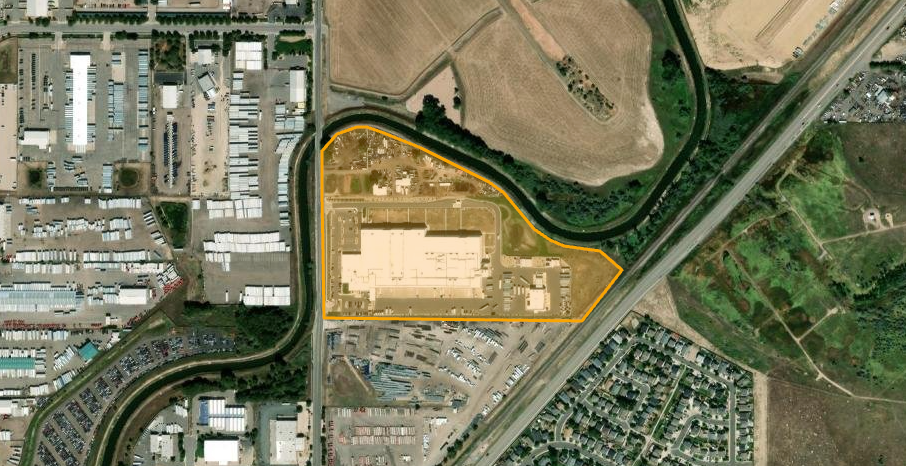
Example RequestLocation_requested: "requested_address_text": "9940 Havana St, Commerce City, Colorado, 80640
HTTP response
HTTP/1.1 200 OK
content-type: application/json; charset=utf-8
date: Tue, 24 Mar 2026 15:41:35 GMT
request-context: appId=cid-v1:e44d0560-b80d-4cdd-a8c0-8b8158f95bbf
transfer-encoding: chunked
x-ms-middleware-request-id: 00000000-0000-0000-0000-000000000000
{
"geofence": [{
"clientId": "XXXXXXXX",
"location_requested": {
"requested_address_text": "9940 Havana St, Commerce City, Colorado, 80640"
},
"location_found": {
"found_address_text": "9940 Havana St, Commerce City, Colorado 80640",
"found_street_number": "9940",
"found_street_name": "Havana St",
"found_locality": "Commerce City",
"found_region": "Colorado",
"found_postal_code": "80640",
"found_country_code": "US",
"found_longitude": -104.864654,
"found_latitude": 39.877041,
"found_geolocationboundary": "{\"type\":\"Feature\",\"properties\":{\"_azureMapsShapeId\":\"146490ca-02d0-4897-83d2-5704411ff4ae\",\"label\":\"9940HavanaStreet,CommerceCity,CO80640-8\",\"color\":\"RGB(243,157,43)\",\"selected\":true},\"id\":\"146490ca-02d0-4897-83d2-5704411ff4ae\",\"geometry\":{\"type\":\"Polygon\",\"coordinates\":[[[-104.86529456857767,39.87803548725347],[-104.86525165323327,39.8760100343562],[-104.85972630266302,39.875960632318595],[-104.85886799577791,39.87679222854064],[-104.85934006456458,39.8771133372546],[-104.86010181192505,39.877195672579916],[-104.8604022193347,39.8772862413239],[-104.86074554208874,39.87746737845251],[-104.86140000108821,39.87806018752926],[-104.86172186617004,39.87824955601553],[-104.86234413866151,39.87849655760306],[-104.86317025903801,39.87880119166911],[-104.86397492174231,39.87904819126976],[-104.86433970216855,39.879146990860846],[-104.86454355005358,39.87915522415392],[-104.86497270349582,39.879039957964295],[-104.86513363603704,39.87889175829275],[-104.86530529741407,39.8787600249826],[-104.86529456857767,39.87803548725347]]]}}",
What This Enables
For years, Kestrel customers have used this API to eliminate the friction of geofence creation entirely.
Instead of:
- Drawing polygons manually
- Managing inconsistent shapes
- Maintaining location data by hand
They rely on a fully managed polygon database that delivers consistent, high-quality geofences every time.
Why This Matters
Remove Manual Effort
- Polygon creation does not scale manually, and it never has.
- Our API replaces hours or years of manual work with a single integration.
Improve Accuracy at the Source
Circle-based geofences introduce noise:
- False arrivals
- Missed departures
- Unreliable triggers
Polygon boundaries reflect the real-world footprint of a location, which leads to better data from the start.
Build Data You Can Trust
Everything downstream depends on geofence accuracy:
- ETAs
- Dwell time
- Operational alerts
- Reporting
- Workflows
- Communications
Clean inputs lead to reliable and trusted outputs.
Scale Without Rework
Whether you're onboarding:
- 100 locations
- 10,000 locations
- Hundreds of thousands of sites
The same API handles it with no process changes required.
FAQs
What if I only have coordinates?
No problem. Pass Coordinates directly and we will handle the rest.
Can I mix polygons and circles?
Yes. Many teams use polygons for high-value locations and circles where simplicity is sufficient.
Why invest in polygons at all?
Without them, you risk:
- Bad operational data
- False triggers
- Missed events
Polygons create a reliable foundation for everything that follows.
What’s Next?
While this API has been a core part of Kestrel’s platform for years, we continue to invest in:
- Expanded location coverage
- Faster processing speeds
- Deeper integrations across telematics and logistics systems
Our focus remains the same: Turning raw location inputs into reliable, real-world boundaries.
Conclusion
Automated polygon geofencing is not something Kestrel just introduced. It is something we have refined over years of real-world usage.
With a single API call, you can:
- Submit a location
- Receive a structured response
- Access a precise polygon
- Store and scale geofences effortlessly


.svg)


.svg)


.svg)

