


Introduction
Kestrel Insights brings automated polygon geofencing to Descartes MacroPoint™, giving freight teams greater confidence in when shipments arrive, depart, and dwell at facilities.
By integrating Kestrel’s geofence libraries into MacroPoint, customers can access facility-specific polygon boundaries that more closely reflect real-world operating locations for every load. The result: more reliable shipment milestones and a stronger foundation for transportation workflows.
For shippers, brokers, carriers, and logistics providers, this integration puts precise geofencing where it can actually make a difference, within the freight visibility platform your team already uses and trusts.
Integration Overview
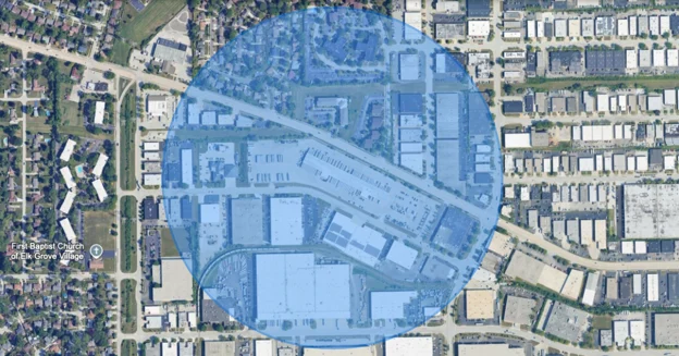
Freight facilities rarely fit neatly inside a circle. A radius-based geofence may include a nearby highway, an adjacent warehouse, or property unrelated to a shipment’s destination, in extreme scenarios it could include 2-5 miles! That can make it difficult to distinguish a truck passing nearby from one arriving on-site.
Manually drawing polygons can help, but maintaining those boundaries across a growing network takes time and resources.
Kestrel’s automated polygon geofences address these challenges by providing boundaries that more closely match actual facility footprints.
From this:
To this:
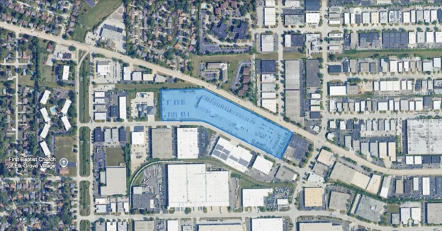
Through our integration with MacroPoint, those boundaries help improve how shipment activity is interpreted at warehouses, distribution centers, manufacturing sites, and other complex freight facilities.
Better boundaries support better location events. Better location events give your team more dependable information to act on.
Where MacroPoint Customers Can Find Value
Reduce manual effort
Stop spending valuable employee time drawing geofences and validating questionable circular based geofence location events. Automated polygon geofencing helps your team focus on managing freight, resolving exceptions, and serving customers.
Improve confidence in shipment milestones
A truck passing a facility on a nearby road should not be confused with a truck arriving at its destination. Facility-specific boundaries help MacroPoint detect arrivals and departures more accurately, giving your team greater confidence in shipment progress and customer communications.
Strengthen dwell visibility
Understanding how long a truck spends at a facility starts with dependable arrival and departure events. More precise geofencing supports clearer dwell reporting, helping teams identify detention risks earlier and understand where delays occur.
Get more value from workflow automation
Notifications, status updates, and downstream integrations depend on the events that trigger them. Improving event accuracy helps teams automate with greater confidence and spend less time correcting misleading updates.
Scale your geofencing strategy
Maintaining boundaries one location at a time becomes difficult as your network grows. Kestrel’s automated approach helps support expanding location needs without a matching increase in manual work.
FAQs
- Does Kestrel replace MacroPoint or my existing tracking solution?
No. Kestrel complements your existing technology. MacroPoint delivers freight visibility, while Kestrel provides precise facility boundaries that help make location data more useful.
Your team can continue working within its existing environment, with greater confidence in the location events supporting daily operations.
- What if circular geofences still work for some of our locations?
Different locations can have different requirements. Our team can help identify where polygon geofencing would provide the most value, particularly at complex facilities where circular boundaries include neighboring properties or nearby roads.
Contact Kestrel and MacroPoint to discuss the right approach for your locations and workflows.
- Why should I invest in polygon geofencing?
Geofence boundaries influence how your business interprets shipment activity. When a boundary includes unrelated roads or neighboring facilities, it can contribute to misleading milestones, unreliable reporting, and unnecessary manual review.
A polygon geofencing strategy helps establish a stronger foundation for arrival and departure detection, dwell analysis, and the workflows that depend on those events.
- Is this relevant for smaller operations?
Yes. Time spent drawing boundaries or checking questionable shipment updates adds up at any company size.
Kestrel can help you evaluate your location needs and identify an approach suited to your operation.
- How do I get started?
Contact Kestrel Insights to discuss using polygon geofencing with your MacroPoint environment. Our team can review your use case, identify priority locations, and coordinate the appropriate next steps.
About Descartes MacroPoint
Descartes MacroPoint is a freight visibility platform serving shippers, brokers, carriers, and logistics providers. It helps teams monitor shipment progress across their supply chains and use transportation data to support operational decisions.
The addition of Kestrel’s geofence intelligence strengthens that visibility by helping align location events with actual facility boundaries.
What’s Next?
Kestrel continues to expand access to automated polygon geofencing across the platforms freight and fleet teams depend on.
Our focus remains on making precise location data easier to access and more useful in daily operations. Through integrations like MacroPoint, we’re helping customers connect facility boundaries to the shipment events, reporting, and automation that drive their businesses.
Conclusion
Reliable freight visibility depends on understanding what is happening at the locations that matter.
Kestrel Insights’ integration with Descartes MacroPoint brings facility-specific polygon geofencing into existing freight visibility workflows, helping improve arrival, departure, and dwell detection.
Together, MacroPoint’s tracking capabilities and Kestrel’s geofence intelligence help teams reduce manual intervention, strengthen automation, and make decisions with greater confidence.
Get Started
Ready to put more precise geofencing to work in your MacroPoint workflows?


