


Your truck driver texts “here” from a Starbucks parking lot while your customer is still waiting at the loading dock. Classic Tuesday morning, right?
Things like this happen time and time again, because chances are your tracking system thinks “somewhere in the neighborhood” counts as an arrival.
It doesn’t.
Your customers know it, your dispatchers know it, and you definitely know it when the phone starts ringing with complaints about phantom deliveries and mystery delays.
Polygon geofences, however, cut through this nonsense by drawing actual boundaries around your facilities. Not approximate zones or rough estimates — real perimeters that know the difference between your warehouse gate and the strip mall across the street. When trucks cross these lines, your system captures genuine arrivals, departures, and dwell times that flow straight into whatever telematics platform you’re already running.
Four recent use cases prove it.
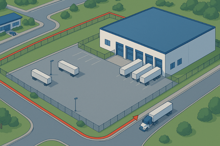
Use Case 1: OTR Trucking Fleets Running Shipper-to-Receiver Routes
Your driver hauls from the Kellogg plant in Battle Creek to the Target DC in Minneapolis. Simple route, right? Except your system shows “delivered” while he’s still hunting for the right dock door in a sea of identical loading bays.
OTR fleets deal with this on every single run because most tracking treats the entire industrial complex like one big arrival zone. Your driver could be at the guard shack, the visitor parking lot, or actually backed up to dock 23 — the system calls it all the same thing.
Kestrel Insights’ polygon geofences outline the entire property footprint at both origin and destination, not a crude radius. When a truck crosses that boundary, you get clean on-site and off-site signals that filter out noise from nearby roads, staging areas, or truck stops.
Your telematics platform can turn those boundary crossings into standard milestones: Arrived at Shipper, Departed Shipper, Arrived at Receiver, Departed Receiver. When you pair them with order or trailer-sensor data, you can also tag moves as departed loaded or departed empty. Every timestamp reflects a real gate crossing, not a best guess.
Use Case 2: Mega Carrier LTL’s Network-Wide Terminal Coverage
Multiply that shipper-to-receiver precision across 213 terminals and you get a taste of LTL operations. When your network moves freight through dozens of terminals every night, “somewhere near the Charlotte hub” doesn’t cut it for dispatch coordination.
Deploying geofences around every terminal location in its national network. Each polygon captures real terminal activity instead of trucks idling at nearby truck stops or circling adjacent parking lots. Dispatchers get reliable arrival notifications that trigger dock assignments, and cut-time alerts fire when trailers haven’t crossed facility boundaries by their deadlines.
The automation runs deep. Standardized arrival and departure events flow straight into route planning systems and driver apps. Planners get clean time stamps to rebalance freight when terminals hit congestion bottlenecks. Manual “where’s my freight” calls drop because the system knows exactly which terminal has which trailer.
Terminal geofences give the location intelligence they needed to coordinate P&D pickups, cross-dock operations, and linehaul departures across their entire network.
Use Case 3: Automated Geofence Creation for Wayward Waste Containers
Managing thousands of recycling bins across customer sites becomes a nightmare when containers drift from their assigned locations. We solve this by running automated reports that identify bins sitting outside established geofences, then instantly create new boundary zones based on those containers' GPS coordinates.
Here's how it works: Our system pulls lat/long data for all bins, cross-references against existing geofences, and flags orphaned containers. For bins outside boundaries, we automatically generate precise geofences around their current positions. This catches stolen equipment, identifies unauthorized relocations, and guarantees billing accuracy when containers migrate to new customer sites.
Fleet managers benefit, too. Instead of manually hunting down missing assets or creating geofences one-by-one, they get real-time visibility into container movements with automated boundary management that scales effortlessly and updates dynamically.
The Pattern Across Every Fleet Type
Notice the common thread? Whether you’re running long-haul routes like the OTR fleets, coordinating terminals, or managing waste containers, the challenge stays the same. Your location data lies to you, and those lies cost money.
Polygon geofencing cuts through this mess by turning sloppy location pings into clean, automated events. Detention claims that stick. Dwell times you can trust. Fewer manual check calls eating up your dispatchers’ day. And at Kestrel Insights, that’s precisely what we deliver with automated polygon geofences straight into whatever telematics platform you’re already running — Samsara, Geotab, Motive, project44, whatever. Point us at an address, get back a vetted polygon that syncs across your entire tech stack, and stop chasing dots around a map.
Contact us today to learn more.


.svg)


.svg)


.svg)

